NoCo Places
A common voice for public lands
Nine county, state, and federal public land agencies from north-central Colorado are actively collaborating to
address the challenges the mountains and foothills in this region are facing from high visitation and a growing
population. We are committed to sustainable solutions, equitable actions, and beneficial land management practices
for the long-term conservation of Colorado’s public lands and the quality of the visitor experience.
Conservation & Recreation Vision
Programs & Workshops
2025 Annual Report
Colorado Outdoor Regional Partnerships Initiative
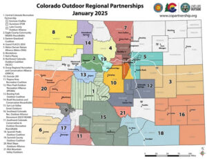
The Colorado Outdoor Regional Partnerships Initiative (RPI) advances regionally driven collaboratives working to ensure that Colorado’s land, water and wildlife thrive while also providing equitable access to quality outdoor recreation experiences. The Initiative convenes broad outdoor interests through Outdoor Regional Partnerships to develop regionally rooted visions and action plans that advance sustainable outdoor recreation and conservation priorities. Combined with Colorado’s Outdoors Strategy, a collaborative vision for conservation, climate resilience, and sustainable recreation, Outdoor Regional Partnerships are informing future investments for Colorado’s outdoors.
NoCo Places is a recognized Regional Partnership in this program. Learn More
Funding
Our sincere gratitude to all of the organizations that have provided NoCo Places with critical funding:
- Colorado Department of Local Affairs
- Colorado Parks and Wildlife
- Great Outdoors Colorado
- The Gates Family Foundation
- The Boettcher Foundation
- The Metro Denver Economic Development Corporation
- Western Resource Advocates
- Jefferson County Economic Development Corporation
- The Colorado Forum
- Mighty Arrow Family Foundation
- Each of the nine agencies that comprise NoCo Places
